I successfully climbed Aconcagua solo via the Normal Route from February 1st through February 14th, 2015, reaching the summit on February 11th. Below are my photographs from the trip organized by date.
Aconcagua

Aconcagua from near the Horcones trailhead.

Sunrise, Aconcagua

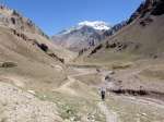
Aconcagua from the trail between Horcones and Confluencia.
January 28th-31st
The hotel at Penitentes, ~2550m, and acclimatization day hikes on the 30th and 31st.

Organizing all of my equipment and food before departing to Argentina.

The Penitentes ski resort.

Birds in the hills.

Dry, interesting terrain.

The ~4000m peak I trekked on the first day at Penitentes. I reached about ~3850m before being stopped by cliffs.

The Hotel Ayelen at Penitentes.
February 1st
Entering the national park and hiking to 3390m Confluencia.
-

-
The national park headquarters and ranger check-in.
-
-
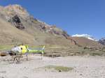
The national park helicopter, Aconcagua shining in the distance.
-
-
Aconcagua from near the Horcones trailhead.
-

-
My little red tent pitched at Confluencia.
-

-
Interesting rock stratification.
-

-
Confluencia camp.
February 2nd
Hiking from 3390m Confluencia to 4300m Plaza de Mulas basecamp.

River Crossing.

The ruins of old basecamp.

First up-close view of Aconcagua.

Helicopter removing waste at Plaza de Mulas.

My tent at Plaza de Mulas.

Arriving at Plaza de Mulas.
February 3rd
Day hiking 5004m Cerro Bonete from Plaza de Mulas.

Cerro Catedral.

Plaza de Mulas from Bonete summit.

Crossing the river.

The boarded up Aconcagua Hotel.

Cerro Bonete.

Approaching Cerro Bonete.

Sunset on Cuerno.

View of Aconcagua and the Normal Route from Bonete’s summit.

Close to the summit of Bonete.
February 4th – 5th
February 4th was my first gear carry and cache to 4950m Camp Canada. On February 5th I made a full move to Camp Canada.

The Conway Rocks, a distinct landmark on the way to Camp Canada.

Cerro Bonete from Camp Canada.

Camp Canada.

Gathering stream water.

Camp Canada vews.

Plaza de Mulas from near Camp Canada.

A heavy load for the first gear carry.

Cuerno from Camp Canada.

Relieved to arrive.
February 6th – 8th
February 6th was my first gear carry and cache from 4950m Camp Canada to 5450m Nido de Condores. On February 7th I made a second carry. On February 8th I made a full move to Nido de Condores.

Melting ice brought down from Nido to Camp Canada.

Lenticular clouds at Nido de Condores.

The medical tent and ranger hut at Nido de Condores.

Climbers descending the slope above Camp Canada.

View towards the summit.

Cerro Cuerno from Nido de Condores.

A frozen meltwater pond.

Sunset at Camp Canada.

Looking up the Gran Acarreo

My tent and wind wall at Nido de Condores.

My tent and wind wall at Nido de Condores.

Nido de Condores.

My tent and wind wall at Nido de Condores.

Peaks and glaciers behind Nido de Condores.

Camp Canada getting crowded as I prepare to move to Nido de Condores.
February 9th – 10th
Acclimatization hike to 5900m Camp Berlin on February 9th, and to 6000m White Rocks / Camp Colera on February 10th.

The huts at Berlin.

Ominous cloud at Nido de Condores.

Huts at Berlin.

The emergency shelter refuge Elena at White Rocks.

Large guided groups at White Rocks camp.

Cerro Cuerno in the clouds.

Cerro Catedral.

White Rocks camp.

Nido de Condores after some snowfall.
February 11th
Climbed to the 6962m summit of Aconcagua from 5450m Nido de Condores taking 8.5 hours, 3 a.m. – 11:30 a.m. Descended to 4300m Plaza de Mulas to rest.

El Dedo, the finger.

Looking down the Gran Acarreo.

Ascending the Gran Acarreo below the Canaleta, the summit above.

Approaching the Gran Acarreo traverse. The summit is ahead and finger rock, el Dedo, is visible mid-traverse.

View from Indepencia.

The Guanacos Ridge connecting the north and south summits. Nicolas Miranda and Karl Egloff can be seen ascending at the bottom-center of the picture.

Looking back across the traverse.

Indepencia Hut.

View down the Canaleta and towards Cuerno from the summit.

Nicolas Miranda and Karl Egloff, two friendly Ecuadorians who were training for an attempt at a record ascent time. They were later successful.

Sunrise from the slope below Indepencia.

Looking down the Gran Acarreo, my route of descent.

Plaza de Mulas zoomed in. My tent is visible, the red spot at center-left, to the left of the ranger hut.

Plaza de Mulas, far below.

Views of distant peaks from the summit.

On Aconcagua’s summit. Stylish down pants – putting them on while wearing gloves I couldn’t easily get them over my thick calf-length boot liners.

Aconcagua from 4300m Plaza de Mulas after my ascent. The weather quickly deteriorated in the afternoon.

The upper Canaleta from Aconcagua’s summit. Ascending climbers are visible in the middle of the frame.

On Aconcagua’s summit.

Zoomed in on White Rocks camp far below.

Descending the Gran Acarreo.

Views of distant peaks from the summit.

Views of distant peaks from the summit.

The summit cross and Aconcagua’s south summit.
February 12th – 14th
On February 12th I reascended from 4300m Plaza de Mulas to 5450m Nido de Condores. On the 15th I packed up camp and descended to Plaza de Mulas. On the 14th I descended to the park gate and returned to Penitentes.

Clear views across the mountains behind Nido.

Prepared for the final descent from Nido de Condores, loaded with garbage, waste, gear, and leftover food.


