Nanhuda Shan – 南湖大山 – February 2012

Nanhuda Shan.

Nanhuda Shan.

Zhongyangjian Shan and Nanhuda Shan

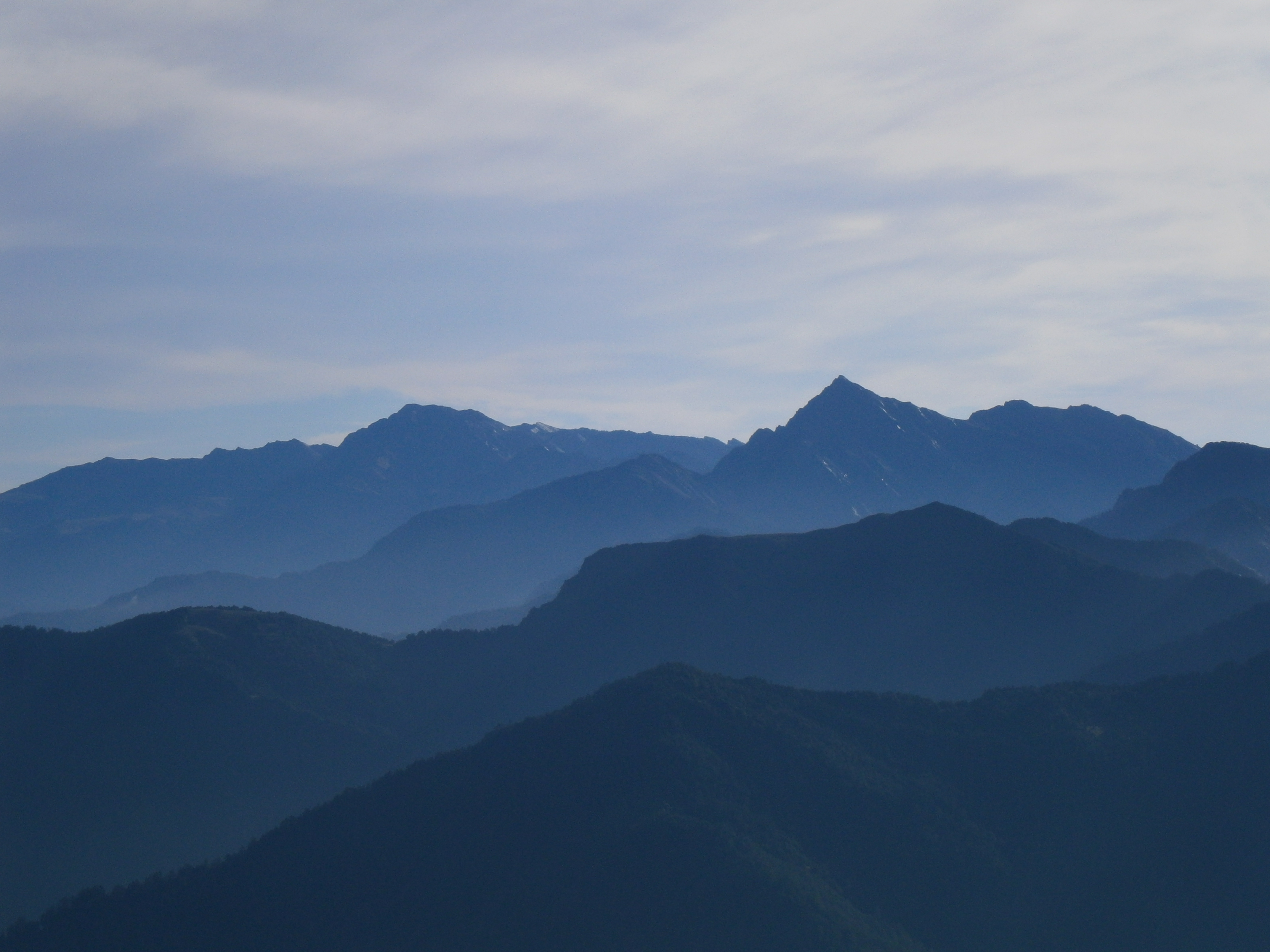
Nanhuda Shan (left) and Zhongyangjian Shan (right) viewed from North Hehuan Shan.

The air was clear, and to the east there was a great view of Nanhuda Shan (left), and Zhongyangjian Shan (right).

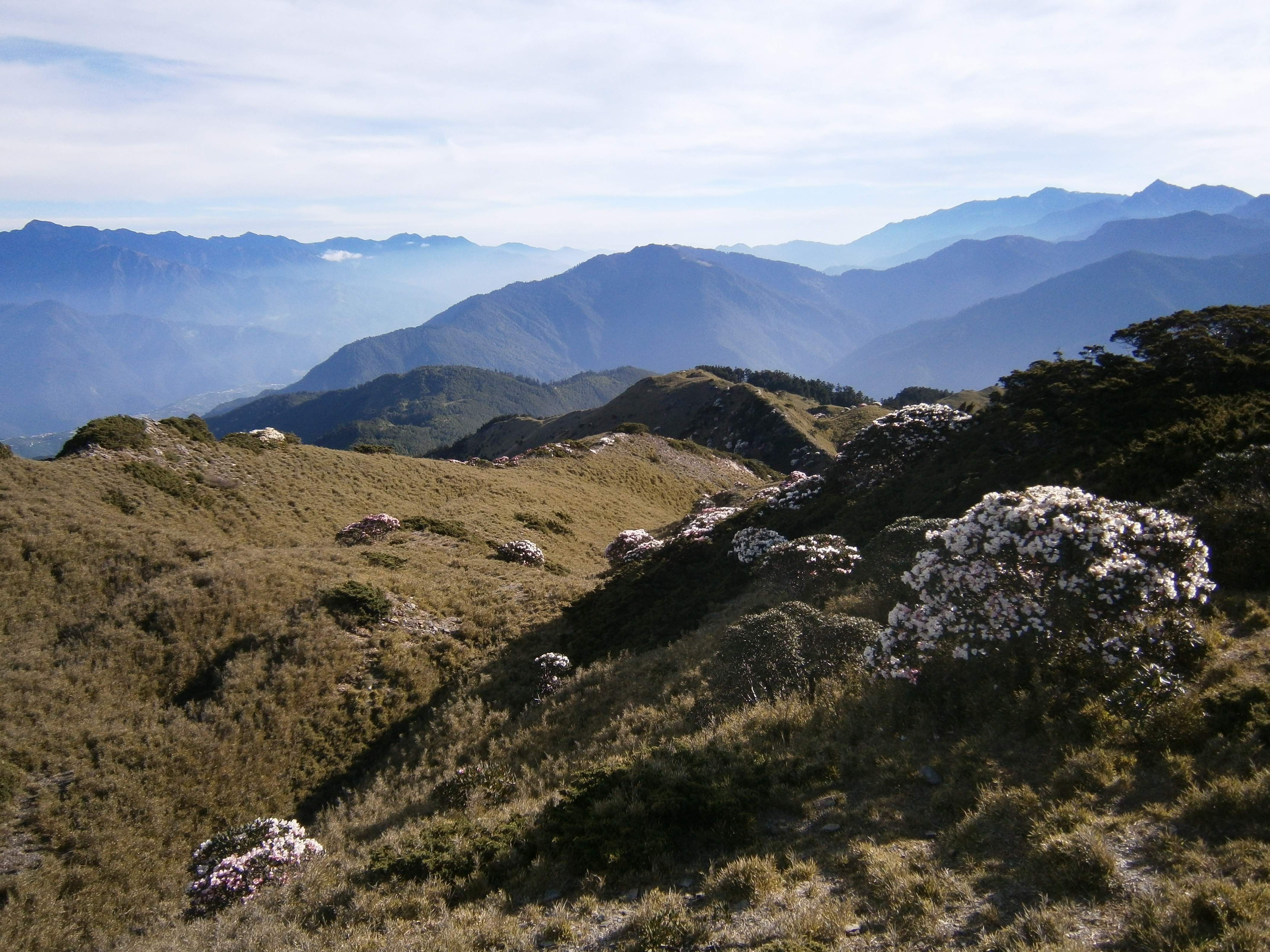
Nanhuda Shan (left), and Zhongyangjian Shan (right) viewed from near Snow Mountain’s East Peak

Nanhuda Shan, Taiwan’s fifth highest at 3742m, is one the most beloved mountains among Taiwanese hikers and is famous for its views and impressive, rocky faces.  Many experienced Taiwanese hikers will tell you that Nanhuda Shan is the most scenic, the most beautiful of Taiwan’s mountains.  I visited Nanhuda Shan in early February, and unfortunately experienced absolutely terrible weather on all four days of my trip.

Walking the entry road near the trailhead on the first day, before the weather turned to soup.

Despite the awful weather, the hiking was exceptional.  The route initially heads up through forest, but breaks the treeline after the first day, leading one across an awesome landscape of barren rock.  In the snow higher up, it was an eerie and severe place.

Here is an outline of my four day hiking route:

My four day hiking itinerary.

Day 0: Caught a train from Taipei to Luodong, in Yilan county, and stayed overnight in an inexpensive hotel.

Day 1: Up early, caught a taxi (NT$2500) from Luodong to the trailhead.  We opted to shell out for a Taxi, rather than rent a much cheaper motorbike, due to the already very unpleasant weather.  Rain showers and thick fog on the drive up.

From the trailhead, we walked 6.7km along an old overgrown service road, long rendered impassable to vehicles due to earthquakes, landslides, and typhoon damage.  Not so much a road as a wide, level hiking path.  Several detours took us off of the road, and over sections wiped out by landslide.  The weather began to worsen, and fog descended over everything.  It began to rain again.

The ‘road’ is overgrown and rough. Mostly level, we covered the 6.7km at a fast pace.

From the “true” trailhead, we hiked another couple of hours to the Yunling cabin, where we would camp for the first night. The Yunling cabin has plenty of bedspace and is well constructed, but we had opted to use our tents.  The weather was wet and wretched, and as night fell it became quite cold.  The temperature hovered around 0C; not quite cold enough for snow, and very unpleasant in the constant drizzle.  I had a good night’s sleep, but the friend who accompanied me this far was feeling ill, and didn’t sleep well.

Yunling cabin, with two friendly hikers whom I met on the third day.  We’re all wet!

Day 2: In the morning, my friend was much worse; he had stomach pain, and could not keep food down.  After much discussion, he decided to accompany another team who was headed home, and get off of the mountain.  The team he went with conveniently lived in Taipei, nearby his house. They gave him a lift all the way home!  I continued alone.

From Yunling cabin, I hiked upwards towards the Nanhu Cabin/campsite, passing Shenmazhen Shan and Nanhubei Shan on the way.

Shenmazhen Shan. Wet from the drizzle.

Nanhubei Shan. Terrible visibility and heavy rain.

Finally reaching the Nanhu Cabin, I pitched camp nearby.  The weather was even worse up high.  Colder, but just as wet.  I headed off to the Main Peak of Nanhuda Shan with two friendly Taiwanese hikers whom I met in the cabin. One, a businessman who spoke fluent English, had hiked Nanhuda Shan twice before, and told me that he had never seen such awful weather!  The route up to the Main Peak was surreal.  The fog was so dense that we could only see a few meters in front of us, and no trail had been broken through the snow.  We climbed up to the saddle between the East and Main Peaks, and then went about the business of finding trail markers, still visible despite the snow.  The terrain was rocky and desolate.

At the Main Peak, soaking wet. Whiteout visibility.

Getting back from the Main Peak took us much longer than it would have in decent weather.  We got lost a few times, and had to carefully backtrack.

Returning to the campsite, I crashed in my tent for a few hours of sleep.  When the sun set the temperature dropped, creating mucky fog and sleet.  It is hard to imagine worse camping weather.

Day 3:

I woke up feeling strong, and decided to take one more trip up the ridge before heading down.  My two new friends from the day before descended all the way to the trailhead, deciding to leave early due to the weather.  The temperature had dropped, freezing everything.  The sleet/rain stopped, but the fog remained.  Visibility was poor – I was completely socked in.  Retracing our route from the evening before, this time I turned east on the saddle, heading over fields of ice and snow towards the East Peak of Nanhuda Shan.  The trail was rough, rocky and almost totally devoid of plant life.  I built rock cairns as I went, to protect myself from getting lost in the low visibility fog.

The East Peak of Nanhuda Shan. Zero visibility!

From the East Peak, I returned to the Nanhu cabin.  There, I packed up my camping gear, and headed back to the Yunling cabin.  It began to rain again. At Yunling, I pitched camp in the rain, cooked a hot dinner inside and went to bed.  I slept like a rock; compared to the freezing sleet and saturated humidity of the night before, the rain was pleasant!

Adjusting my tent pitch, in the rain, on the third evening. Yunling had plenty of space, and I managed a nice comfortable setup.

Day 4: I slept in until 7 a.m., packed up, and hiked out to the trailhead.

Despite the weather, I thoroughly enjoyed this trip. The terrain at Nanhuda Shan is impressive, varied, and exciting higher up.  Hopefully I’ll get some views, and some better photographs next time!

Accessibility

The Yunling cabin is well built and appeared spacious enough for sleeping.  I chose to camp at Yunling, and did so quite comfortably for two nights.  The area around Yunling has space for two or three tents.  Yunling has a reliable water source.  You can book cabin space and camping space during the permit application process.

The Nanhu cabin is quite large, and was very comfortable.  There are numerous spots for camping at the Nanhu cabin, and plenty of space, as well as a reliable water source (a nice stream).  Nanhu campsite is above the treeline and very exposed.  In the high humidity and freezing rain/sleet I experienced, it was definitely not ideal for camping.  There is also a ‘middle’ cabin located between Yunling and Nanhu, the Shenmazhen cabin.

The Nanhuda Shan trailhead is fairly easy to access.  Take a bus or train to Yilan City or Luodong, and rent a motorbike.  A taxi in cost us NT$2500.

Hiking Nanhuda Shan requires national park entry permits from Taroko National Park, as well as Police issued mountain entry permits. The park entry permit requires two Taiwanese group members; one as the “group leader”, and one as the “emergency contact”.  After the first day I did this hike alone (and the friend who accompanied me on the first day isn’t Taiwanese).  My Taiwanese friend was, unfortunately, feeling under the weather and couldn’t make it. The Taroko National Park permit website (In Chinese) is located here:
http://permits2.taroko.gov.tw/welcome/index.aspx
Police permits can be applied for here (In Chinese).  For the website to load, you need to use Internet Explorer and adjust the encoding for ‘Chinese Traditional, Big5′ (found through Page -> Encoding):
http://eli.npa.gov.tw/E7WebO/index02.jsp

Beidawu Shan – 北大武山 – March 2012

The summit of Beidawu Shan, as seen from the ridge-line trail which approaches from the south.

3090m Beidawu Shan (北大武山), located in Pingdong county, is Taiwan’s southernmost 3000m+ mountain. Remarkably prominent, visibly towering over the surrounding area, the  trail up to the top of Beidawu Shan ascends almost 2000m, making for a really solid hike.

The trail winds up over staircases of rock and tree root, crossing a narrow ridge.

This particular mountain is well renowned for its ‘cloud ocean’ in clear weather.  I had great luck with the weather on this trip, and wasn’t disappointed – above the cabin I had fantastic views.  Here is an outline of the route I took:

A map of my two day hiking route.

Day 1: I caught the overnight train from Taipei to Kaohsiung, arriving in Kaohsiung at 6 a.m.  I rented a motorbike in Kaohsiung and drove to the trailhead.  Getting to the trailhead was a nightmare – after passing the Pingdong Train Station and leaving Route #1 (see the linked map below) the road goes through some very rural farming areas, and signage is absolutely horrendous.  I had to stop and ask for directions several times, despite having a map and basic instructions.  If making this trip for the first time, I strongly recommend using a GPS.

For reference, here is a map outlining the route from the Pingdong Train Station to the trailhead: MAP

Past the village of Taiwu, the road up to the trailhead is in poor condition, heavily damaged by typhoon Morakot.  Higher up, the road is impassable due to landslide, and the trailhead has been moved further down the mountain as a result.  The above maps reflect this change.  The lower trailhead adds a few kilometers of steep terrain to the first day of hiking, but overall this wasn’t too bad.  There was plenty of parking space along the road, and the roadside trailhead was clearly marked with hiking tags.

Hiking through the misty lower forest.

The weather was a bit unpleasant on the first day; very humid and muggy, with fog obscuring most of the views.

The trail lower down crosses several landslides. Foggy weather on the first day.

Interesting, twisted trees grew all over the mountainside.

After four hours of hiking, I reached the Guigu Cabin (檜谷山莊), which was very comfortable and well constructed.  I went to sleep at 5 p.m., knowing I had to be up early the next day.

Day 2: I woke up at 2:30 a.m., and began hiking in darkness at 3:30 after cooking a hot breakfast.  The trail from Guigu Cabin, which is located at ~2100m, ascends roughly 1000m up to the top, and is moderately steep. The trail stretches upwards across the mountain before breaking onto the ridge, where I began to enjoy some great views.

Contrasted by trees, the clouds were fantastic.

The horizon looked interesting in the morning light.

The mountain casts a huge shadow with the sunrise behind it.

The shadow of the Beidawu Shan in the morning sun.

Nearby mountains looked small.  At 3090m Beidawu Shan isn’t the highest of Taiwan’s mountains, but it definitely dominates its landscape.

Much higher than anything else nearby.

Mountains peeking out of the clouds below.

The trail on the ridge was interesting, with lots of foliage to navigate.

The ridge was covered in trees and vegetation.

Near the top, some interesting artifacts can be found.  A crumbling war monument, built on the mountain to honor the Aboriginal Taiwanese who fought for the Japanese during the Second World War, occupies a clearing in the trees.  It fits right in with the environment; ancient and overgrown.

The war monument.

An old Japanese shrine also occupies the ridge.  According to signboards posted nearby, the shrine was originally built right on the summit of the mountain, against the wishes of the local Aboriginal Taiwanese, who hold the mountain sacred.  Perhaps due to this transgression, the shrine was repeatedly struck by lightning, and had to be moved lower to its present-day location.  From the shrine, the summit is roughly an hour’s hike away.

The old Japanese shrine.  The summit of Beidawu Shan is visible past the trees to the right.

I reached the top at 7:30 a.m., and spent an hour on top taking in the views, enjoying the sunshine, and eating snacks. The sea of clouds was brilliant, and the sun was bright in the morning sky.

Near the top.

From the mountaintop the clouds seemed endless.

At the top of Beidawu Shan.

I took my time descending, and stopped at Guigu on the way down to cook a hot lunch.

An interesting section of trail just below Guigu Cabin. Severe drops to either side of this narrow stone ridge.

I got back to the trailhead at 2 p.m., making for a long day of hiking with roughly 1000m of ascent and 2000m of descent.  Since I knew where to go, the drive back to Kaohsiung was much faster and more pleasant than the drive in had been the day before.  In Kaohsiung I boarded the train back to Taipei, and had a good long nap on the way home!

Accessibility

From southern Taiwan Beidawu Shan is fairly easy to get to – it is only ~3 hours out of Kaohsiung (assuming you don’t get repeatedly lost, like I did).  From the north, you’re looking at a 6-7 hour car drive, or a train ride, then a motorbike rental, and then a 3 hour drive.  Here is a map outlining the route from the Pingdong train station: MAP

The Guigu cabin (檜谷山莊) is a comfortable and well built mountain hut. Sleeping space inside of the cabin can be reserved through the Forest Recreation website, here (in Chinese):
http://recreation.forest.gov.tw/askformonhouse/AskForMainB.aspx
Reservation needs to be done well in advance, as space fills up very quickly on weekends.  Unfortunately, a Taiwanese I.D. number is required to register for the website, and thus, to make reservations.  If a Taiwanese friend registers and reserves a space in your name, it won’t be an issue if they don’t accompany you on the hike.  Alternatively, several very nice campsites exist below the cabin.  Most of the campsites use wooden platforms, so bring extra guyline if your tent isn’t freestanding.

Hiking Beidawu Shan doesn’t require a National Park entry permit.  However, it does require a police-issued mountain entry permit.  There are two ways to obtain this.  The easier method, is to apply in advance through the police website.  For the website (in Chinese) to load, you need to use Internet Explorer and adjust the encoding for ‘Chinese Traditional, Big5′ (found through Page -> Encoding):
http://eli.npa.gov.tw/E7WebO/index02.jsp
Alternatively, you can visit any Pingdong police station in person, on your way to the mountain, and fill out the paperwork by hand on the day you plan to begin hiking.  I strongly urge that this only be considered a last-minute option.  It is much faster and easier to do this online.

Snow Mountain Main Peak – 雪山主峰- January 2012

The north shoulder of Snow Mountain, as seen from the glacial cirque at its base.  This photo was taken during my December 2010 trip.

At 3886m Snow mountain (雪山) is the second highest mountain in Taiwan.  So named due to the heavy snowfall it can experience during the winter, the Snow Mountain trail hosts some of Taiwan’s most beautiful hiking.  Across snowfields, into an ancient forest, and finally up through a unique glacial cirque, the east Snow Mountain route takes one through several ecological zones and some marvelous terrain.

The mountain had seen heavy snowfall just prior to our trip.

Last year, in December, I made a trip to this mountain with a group of five friends.  Cold weather and icy conditions made for a real adventure to the summit.  This year’s trip promised to be equally exciting.  I expected the January weather to present a real winter landscape, and I wasn’t dissapointed.

Heavy snow in the black forest.

Here is an outline of our hiking itinerary:

Our three day hiking route.

Day 1: We started our trip with a four hour bus-ride from Taipei to Wuling farm in Shei-Pa National Park.  The cherry trees were in full blossom.

Cheery trees in bloom at Wuling Farm

From Wuling Farm we hitched a ride up to the trailhead.  Our plan involved a short 2 km hike from the trailhead to the Chika mountain cabin, where we would spend the night.  The second day, we would hike 8.9 km from the Chika hut to the summit, and then 3.8 km back down to the 369 hut, where we would spend the second night.  On the third day, we would hike 7.1 km back to the bottom.  The trail to Chika was short and easy – time permitting it is much better to hike to 369 hut on the first day.

The short trail to Chika runs through some nice forest.

The hunchback of Chika Cabin. We had some time to kill!

Day 2: At Chika we woke up at 3 a.m., and after breakfast, hit the trail at 4:30 a.m.  Above Chika, the air became colder, and we got our first glimpses of snow.

The trail above Chika gave us our first glimpse of snow.

The trees were very beautiful.

The air wasn’t perfectly clear; a thin mist hung over everything.

We reached 369 cabin and found it mostly empty.  A park ranger greeted us, and warned that the weather had been poor higher up in recent days.

369 Cabin was blanketed.

A snowy landscape.

Above the 369 hut, we entered the black forest, a beautiful and haunting place in the winter.  On our way through the forest, we met a team of five climbers from Hong Kong, on their way back.  They didn’t greet us or smile.  We would learn later that they had gotten past the forest, but had decided to turn around due to the poor visibility.

The Black Forest.

The path through the forest.

It was hard to believe we were still in Taiwan!

Huge icicles in the black forest.

The snow became deeper and deeper.  Undeterred, we pushed onwards.

The snow was getting deeper.

After the forest we reached the primary glacial cirque, a unique ‘bowl’ formation at the base of the ridgeline which marks the final leg of the route to the summit.  It began snowing when we arrived in the cirque, and in places the ground was covered with a good 2 feet.  Visibility was very poor, but our spirits were high.

At the cirque, the weather quickly worsened.

The ridgeline above us was invisible due to the snow, and the trail markers were buried.  I had hiked this route before, and knew where we needed to go.  We forged along the face of the mountain, headed south-east towards the ridge, kicking and stomping footholds.  The poor visibility made the going slow.

Heading up to the Main Peak of Snow Mountain.

Finally, I saw the ridgeline and we burned a trail straight to the top.  We were a bit unsure whether we were north or south of the summit – but a quick hike confirmed that we were to the south.  Ten minutes later, we were at the peak.  All three of us made it, and it felt like a real accomplishment.

On Snow Mountain Main Peak.

We got back to the 369 hut one hour before nightfall, right on schedule.  In all, we had been hiking for roughly 12 hours – slow due to the visibility.

Day 3: The next morning we woke up at 6 a.m., and hit the trail at 8 a.m. – plenty of time to cook a nice breakfast.  On our way down, the weather cleared up a little bit.  The Ranger at 369 took off for the summit, keen on what appeared to be a break in the weather.

A view of the ridge – the main peak obscured by clouds – on the way back down.

Clouds were billowing past, and we had interesting views on the way down.

Under blue skies, the landscape was very pleasing.

As we descended the air warmed at lower altitude and the snow slowly disappeared.  We found ourselves enjoying the sunny pine forest which we had hiked mostly in darkness on the first two days.

Lovely sunshine warmed us up.

The forest was cool and refreshing.

Our adventure complete, and successful, we caught our bus back to Taipei!

Accessibility

The 369 cabin is large, and while basic, is fairly comfortable.  There is a reliable water source at both Chika and 369.  Hut space can be booked online, during the permit application process.

Wuling Farm, where the trailhead is located, is fairly easy to access.  We took a bus from Taipei to get there (~4 hours).  Be warned that buses don’t run to the trailhead itself, only to the Wuling Farm visitor center.  It is fairly easy to hitch a ride up to the trailhead – try politely asking the park staff.  More information on the bus we took here (in Chinese): http://www.wuling-farm.com.tw/location/index.php

Hiking Snow Mountain requires a national park entry permit, as well as Police issued mountain entry permits.  Both are easy to apply for.  The Shei-Pa National Park permit website (in Chinese) is located here, and offers a very intuitive, easy to follow interface (perhaps the best of all Taiwan’s national parks):
https://apply.spnp.gov.tw/
Police permits can be applied for here (In Chinese).  For the website to load, you need to use Internet Explorer and adjust the encoding for ‘Chinese Traditional, Big5′ (found through Page -> Encoding):
http://eli.npa.gov.tw/E7WebO/index02.jsp

North / West Hehuan Shan – 北合歡山 / 西合歡山 – April/May 2012

Looking out over the Hehuan Shan.

The Hehuan Shan mountain range is a popular tourist spot in Taiwan. Well known as home to the country’s highest road, several of the area’s mountaintops are easily accessible.  The Hehuan mountains are famous for their heavy snowfall in the wintertime, and vibrant rhododendron flowers in the spring. The Hehuan range is quite exposed, and receives more snowfall (and generally inclement weather) than most of Taiwan’s other mountains.

Rhododendrons and a great view.

In April I headed to Hehuanshan with a friend to hike the North-West ridgeline – a camel back of ups and downs, all over 3100m in elevation. The plan just barely fit into my weekend; I’d be able to get there Saturday, camp out on the ridge overnight, hike all day Sunday, and get home at a reasonable hour.  The April hike was so enjoyable, that I went and did it again in early May, this time with my friend Richard.  This journal provides a rough outline of both hikes.

Here is an outline of the itinerary we took for both trips:

A map of our two day itinerary.

Day 1: Both trips started with a ~4 hour bus from Taipei to Puli, a motorbike rental in Puli, and a 2 hour drive to the trailhead.  From the trailhead, we hiked for an hour or so to the North Peak, and then pitched camp nearby.

In clear weather Snow Mountain is visible from the North Peak of Hehuan Shan.

Chilai Shan’s North Peak (left) and Main Peak (right) can also be seen.

Day 2: Up early, we hiked across the entire North-West ridge, from the North Peak to the West Peak and back.  The West Peak has a great little sheltered spot to stop and eat lunch in a nearby patch of trees.  From the trailhead, we drove back to Puli, and caught a bus back to Taipei.

In clear weather, the views of surrounding terrain are lovely.

On both trips, we pitched camp nearby the 3422m North Peak.  There are lots of comfortable spots for this (albeit, none with a water source); don’t settle for the first one you see if it isn’t perfectly level!

Our very comfortable campsite on the April hike.

Our campsite for the May hike – not the best tent pitch, as the ground wasn’t perfectly level and the bushes prevented proper guy-line use.

The north-west ridge of Hehuan Shan is perhaps the only moderately challenging hike the Hehuan mountains have to offer.  Four of the nearby peaks offer trails which can be completed in between fifteen minutes and two hours, but the north-west ridge offers a solid 8-9 hour day of good hiking over very enjoyable terrain.

Many people come up the North Peak to take photographs of the flowers and beautiful terrain.

After waking up and eating breakfast, we set off west along the ridge, headed towards the 3145m West Peak.  The “West Peak” isn’t much of a mountain, more just the western-most termination point of this particular ridge.

Looking back at the North Peak behind us.

The trail continuously drops and climbs, and has five big ‘humps’ to travel over before reaching the West Peak.  The terrain is very aesthetic, with pastoral fields, intermittent pine forest, and Yushan cane. On both hikes, the rhododendrons were blooming, and their pink flowers were a common sight along the trail.

Rhododendron flowers.

Rhododendron flowers.

Patches of pine forest cover parts of the trail.

At times, the trail is quite steep.  With the entire ridge above 3100 meters, it makes for great exercise.

Heading down the ridge.

Some great views in clear weather. Nanhuda Shan and Zhongyangjian Shan.

Knowing that the objective of the hike, the diminutive and unimpressive West Peak, was somewhat uninspiring once achieved, we brought along snacks and a nice beer on both hikes.

The softly rounded West Peak in the distance. Zoom in and you can see some hikers on top.

About to enjoy a cold beer on the West Peak!

Accessibility

In great weather, this is a truly fantastic day hike.  Logistically, it takes some time to get to the trail, and might be best if done as a relaxed two or three day trip, with some time spent exploring the smaller trails in the area, or enjoying the high-end facilities of nearby resorts.  The cheapest way to get there, is to drive a car, or take a bus to Puli and rent a motorbike.  The North Peak trailhead is hard to miss, and is located right near the 37km marker of route 14, well past the Songsyue mountain lodge.

The North Peak offers some great terrain for camping.  Some of the best spots are just off the trail on the south side of the North Peak, a short distance below the top.  Unfortunately, there are no reliable water sources.

There are no national park permits for this particular hike, although a police-issued mountain entry permit is required.  There is nobody up there to check for it though, and it seems highly unlikely that anyone bothers with it, given the fairly crowded area around the base of the North Peak.  Police permits (In Chinese) can be applied for here.  For the website to load, you need to use Internet Explorer and adjust the encoding for ‘Chinese Traditional, Big5′ (found through Page -> Encoding):
http://eli.npa.gov.tw/E7WebO/index02.jsp

Jade Mountain Seven Peaks – 玉山七峰 – April 2012

Jade Mountain’s Main Peak.

Jade Mountain (玉山), Taiwan’s highest mountain at 3952m, can also be considered the high point of its own small mountain range.  I’d climbed the remotest, seldom visited pair of  mountains on this range, 3081 meter Xiluanda Shan (西巒大山), and 3263 meter Junda Shan (郡大山) a few weeks before this trip, and had already climbed the Main Peak of Jade the past December, forging through unpleasant weather to get to the top.

A landslide-prone trail segment on the way to the Main Peak.

April is the beginning of spring in Taiwan, and prime hiking season. A return trip to Jade Mountain seemed to be a good idea, and I slowly put together an interesting itinerary for a three day trip. I made a plan; climb all seven of the 3000+ meter peaks near Jade’s Main Peak (saving the southwest Nanyu Shan and southeast Lu Shan for a later trip, given the additional two days required to reach them) in three days.

After hours of paperwork and correspondence with the Yushan National Park to acquire the necessary permission and park entry permits, the plan solidified. A few friends also decided to join me for the main summit.

Here is an outline of the hiking plan:

A map of my three day route.

Day 0: Caught a bus from Taipei to Jiayi, and met a friend who conveniently lives nearby. Rented motorcycles, and drove three hours from Jiayi to the Tataja trail-head, went to sleep early in the Dongpu mountain hostel.

Day 1: Started hiking up the restricted-access service road to the start of the trail at 4 a.m., slow with a heavy pack of camping gear and food (We ate very well; a gourmet – but heavier – menu of dumplings, meatballs, soup, noodles, canned fish, cheese, cookies, pizza, and an abundance of chocolate and snacks). A tiring beginning!

Feeling sleepy, walking the police road to the trailhead.

I reached the first trail split at 7 a.m., slightly ahead of the others, dropped my pack and burned up a steep trail of big boulders and scree to the first mountaintop of the trip, the Front Peak (3239m). The view wasn’t much to speak of, but the path up was a really fun scramble over huge rocks. Back on the trail by 8:30 a.m., caught up with everyone by ~10 a.m.

Jade Mountain’s Front Peak, seen from higher up the trail.

On top of the Front Peak.

We had wonderful weather, and on the way to our campsite the clouds parted for a moment, revealing Jade Mountain’s distant Main Peak, bathed in sunlight.

The Main Peak in a patch of sun.

Reached the Yuanfong campground (above the treeline at ~3600 meters) at 1 p.m., where I unloaded and pitched camp.  I left Yuanfong alone at 2 p.m., heading south towards the South Peak and Dongxiaonan Shan, the second and third mountains on my schedule. Clouds were rolling in, and the temperature dropped sharply.

The ‘trail’ along the south ridge of Jade Mountain is wild and unmaintained – almost nonexistent for long stretches – a compass is mandatory for hiking here. The ridge itself is made up of loose scree and boulders. Numerous ‘teeth’ and cliffs break the ridge apart, making it difficult to follow.

The south ridge of Jade is jagged and sharp, featuring many eerie rock ‘teeth’.

I reached the base of the barrel-like South Peak (3844m) at 2:30 p.m. It was definitely one of the hardest peaks of the trip, with some scrambling to the top.

The route up the South Peak. Steeper than it appears pictured here!

On top of the South Peak of Jade Mountain.

Continuing south towards Dongxiaonan Shan, the weather worsened and thick cloud descended.  Visibility was very poor.  I reached the top of Dongxiaonan Shan (東小南山, 3744m) at 4 p.m. The name of this mountain doesn’t translate well; it literally reads “East Small South Mountain”. An easy mountain to climb, it was a bit difficult to find due to the fog and twisting ridge. In stark contrast to the South Summit, Dongxiaonan Shan is a softly-rounded dome.

On top of Dongxiaonan Shan.

Returning to Yuanfong the trail was immersed in fog, and I spent ~45 minutes lost, just blindly following the jagged ridge-line north with no trail, using my compass to keep course. I got back to Yuanfong at 6:30, exhausted, and went to sleep after cooking up some hot dinner.

Day 2: Started hiking at 8:30 a.m., headed North towards the Main Peak. It was a clear, beautiful day, and the switchback trail up to the Main Peak, as well as the Peak itself, were both visible in the distance.

The route from Yuanfong towards the Main Peak.

With very clear air, we had excellent views south towards Yuanfong. The trail to Yuanfong is clearly visible.

We reached Jade Mountain’s 3952m Main Peak at around noon, and spent an hour celebrating, eating snacks, taking pictures, and enjoying the view.

At the top of the Main Peak.

Our group parted ways at 12:45 p.m.  Two of my friends hadn’t slept well, and decided to descend to the trailhead and return home. The remaining two of us had slept like a pair of rocks in my tent, and were feeling well fueled by heaps of dumplings, meatballs, and noodles, so we were sticking to our plan. The next objective on my schedule was the impressive East Peak of Jade Mountain. It was clearly visible from the Main Peak, and looked daunting.  I descended Jade’s east face alone, sliding down steep scree to the eastern saddle. The summit of the East Peak, marked by a cairn of rocks, was clearly visible in the distance.

The East Peak, seen from the eastern saddle.

A close up of the East Peak.

On top of the East Peak, the Main Peak in the background.

I reached the top of the East Peak (3869m) at 2 p.m. – a steep, exhilarating, and thoroughly entertaining climb to the top, and worth it for the views.

I returned to the sheltered East Peak trail-head at 3 p.m., where I met my friend. Together, we descended the north ridge, headed towards the North Peak of Jade Mountain. It was cold and windy!

Covered up in the wind.

Taiwanese hikers sometimes do things a little bit differently than Westerners. For one, rainboots are widely regarded as footwear well-suited for hiking. This makes sense, when one considers Taiwan’s consistently inclement weather, mud, leeches, and sharp rocks. Rainboots are cheap, waterproof, and difficult to ruin. A Taiwanese friend whom I’d met climbing on Snow Mountain and Beichatian Shan (he was using his own pair of rainboots to hike in deep snow and sub-zero weather on Snow Mountain in January!) helped us out for this trip, and gave my friend a pair of top-end rainboots for climbing Jade. Not your standard rainboots, these have thickly padded insoles, grippier outsoles, and bold styling: the Chinese says “Legendary White Rainboots”.

Legendary white rainboots.

In addition to great views of the Main peak, the East Peak was clearly visible from the north ridge trail.

The Main Peak towers above the north ridge.

The East Peak was prominent and clearly visible from the north ridge.

We reached the North Peak (3858m) at around 5 p.m.  We had amazing views of the North ridge, the Main Peak, the East Peak, and a billowing sea of clouds.

On the North Peak of Jade Mountain.

Our view of Jade Mountain’s Main Peak and East Peak.

The sea of clouds north of the North Peak stretched into the horizon.

We took our time returning to Yuanfong, enjoying a bright moon and near-cloudless sky full of stars. We got back to camp at 9:30 p.m. – a long 13 hour day for me, and a solid 11 hours for my friend.

Day 3: Packed everything up, and started hiking at 8:30 a.m. We still had perfect weather!

All packed up, we departed Yuanfong. The hut (and water source), seen here, is very basic – our tent was far more comfortable.

Looking down at the Yuanfong campsite.

We reached Paiyun lodge at 10 a.m., and took a break. The lodge is placed for the convenience hikers who only wish to climb the Main Peak of Jade Mountain, and was  under renovation at the time of our trip. When it is completed, the mountain’s Main Peak will be very accessible, and much, much easier. The campsite we used adds another ~2 hours round-trip to any overnight trip involving the Main, North, or East peaks, but is conveniently located with access to the southern ridge.

Paiyun lodge, right on the western saddle. The west ridge and the West Peak are to the left.

We reached the West Peak (3518m) at noon, and were back at Paiyun to cook up a hot lunch by 1 p.m.

On the West Peak of Jade Mountain.

Descending, we reached the trailhead and our motorcycle at 5 p.m. A long drive, followed by a longer bus ride, and we were back in Taipei at 3 a.m.  This trip was better than I could have imagined.  My friends had a fantastic time, the weather was perfect, our food was delicious and worth carrying, and all four of us accomplished our respective goals.

Loaded up with camping gear on the way out.

Accessibility

We chose to use the Yuanfong campground, and brought a tent.  Yuanfong campground is above the treeline, and thus is very cold and windy year-round, but has plenty of space for pitching.  If one desires, “bedspace” (I use that term very loosely – you sleep on the floor) at the Yuanfong hut can be booked.  At the time of writing, the Paiyun cabin – the use of which would make climbing the Main Peak easier – is still closed for construction.  It will probably open soon.  Using Yuanfong to overnight is a viable alternative to Paiyun, although it does add a good ~2 hours of hiking on the first day.  Yuanfong has a reliable water source; the rainwater reservoirs were half full when we visited, despite the dry weather which the area had been experiencing.  It is also possible to make a single-day ascent/descent of the Main Peak (and, with determination, probably one of the East, or North, or West peaks as well), provided you can illustrate experience and physical fitness  – email the permit application staff through the Yushan National Park website (linked below) to obtain the paperwork for this.

The Dongpu hostel (東埔山莊), located at the base of the mountain near the restricted-access service road, is very comfortable, and even provides warm bedding.  Bedspace can be booked, their phone number is 0492702213.

Getting to the trailhead isn’t difficult.  We took a bus to Jiayi, rented motorbikes, and drove ~3 hours to the trailhead.  This is by far the least expensive means of getting there!

Hiking Jade Mountain requires a national park entry permit, as well as police issued mountain entry permits.  Jade Mountain is a popular hike, and it is difficult to obtain a weekend permit; with Paiyun under construction, the number of hikers allowed access per day is limited.  Plan on going during the week.  The Yushan National Park permit website (in English) is located here:
http://mountain.ysnp.gov.tw/english/CP_how.aspx?pg=03&w=2&n=23001
Police permits (In Chinese) can be applied for here.  For the website to load, you need to use Internet Explorer and adjust the encoding for ‘Chinese Traditional, Big5′ (found through Page -> Encoding):
http://eli.npa.gov.tw/E7WebO/index02.jsp

Wuling Sixiu Mountains – 武陵四秀 – May 2012

The Sixiu ridge. Visible from left to right are Pintian Shan (3524m), Chiyou Shan (3303m), and Tao Shan (3325m). Kelaye Shan (3133m) is located north-east of Tao Shan, and thus is not visible.  Photo from my 2010 Snow Mountain trip.

Taiwan’s Snow Mountain range is one of Taiwan’s most beautiful, and in good weather has some absolutely stunning landscapes.  The Wuling Sixiu (“four shows”) are a set of four 3000+ meter mountains – Pintian Shan (3524m), Chiyou Shan (3303m), Tao Shan (3325m), and Kelaye Shan (3133m) – located on a ridge east of Snow Mountain, so named due to their prominence and visibility from the Wuling Farm recreational area.  We set off to climb all four of them over three days, with two nights spent camping on the ridge.

Pintian Shan.

A view of Pintian Shan from the eastern Snow Mountain trail. Photo taken on my 2012 Snow Mountain North hike.

The route involves some awesome terrain: hemlock forests, sheer cliffs, and alpine meadows.  We had great weather for all three days, and enjoyed scenic views of surrounding mountains throughout the trip.

Here is an idea of the trip itinerary:

Our three day hiking route

Day 1: Our bus departed Taipei at 7:30 a.m., arrived at Wuling farm around 11:30. We hitched a ride to the trailhead, and began to climb the 3.5km Chiyou trail to our campsite. We arrived around 4 p.m., pitched tent, and headed towards Xinda cabin to get water. The water run was a much longer mission than expected, and took us a solid ~4 hours round trip, longer due to rough terrain in darkness, and a few short stretches of being lost. We were lucky; the moon was startlingly full, the sky was clear, and the stars were brilliant.

Our campsite. Very comfortable, but no water source.

Finally at Xinda cabin, where we picked up a good 10L of water. Feeling tired, but we still had to carry it all back to camp!

Day 2: Up at 5 a.m., on the 3.1km trail to Pintian Shan by 6. We reached 3303m Chiyou Shan at 6:15, and stopped to take photographs of the scenery. The sky was blue and very clear, affording good views of the surrounding mountains.

The view from Chiyou Shan was impressive. Snow Mountain to the left, Snow Mountain’s North Peak and Pintian Shan to the right.

A close up of Snow Mountain, as seen from Chiyou Shan. The main peak of Snow is the soft, broad ridge to the left. The more prominent right-hand ridge is the north shoulder. The trail up to the top of the main peak is visible.

Mighty Zhongyangjian Shan’s prominent pyramid towered in the distance, and this day’s constant views of it amplified my desire to climb it.

Zhongyangjian Shan in the distance.

From Chiyou Shan, we headed to Pintian Shan.

Pintian Shan in the distance.

A good view of Tao Shan and Chiyou Shan, on the way to Pintian Shan. Chiyou Shan is the closer mountain, Tao Shan is the grass-covered peak behind it.

To get to Pintian Shan, you need to go up and down a steep cliff. It is a lot easier than it looks.

At the base of Pintian Shan.

We arrived at the top of 3524m Pintian Shan around 9:30 a.m. Pintian Shan overlooks the holy ridge, and more great views were had. Mutelebu Shan was particularly ominous looking.

Dabajian Shan and Xiaobajian Shan were clearly visible from the top.

Xiaobajian Shan and Dabajian Shan.

Mutelebu Shan was particularly eye catching.

Stunning Scenery – on the way back to camp from Pintian Shan.

From Pintian Shan, we returned to our campsite, arriving at around 12:00. We cooked up a hot lunch, and I departed for Tao Shan, 2.3km away, at 12:45.  Unsure what the trail terrain would be like and conscious of the time, I arrived at the top of 3325m Taoshan at around 1:50.

Tao Shan in the distance. This photo was taken during my December 2010 Snow Mountain trip.

The clouds rolled in after lunch, and I burned off to Taoshan. With daylight limited, I practically ran there.

From Taoshan, the trail dropped, and continued up and down another 3.5km through pine trees and thick Yushan cane to 3133m tree-covered Kalaye Shan, where I arrived at around 3:45 p.m.

Looking back at Tao Shan, from the Kalaye Shan trail.

Heading back, I arrived at our campsite around 7:15 p.m. – a long ~12 hour day of hiking.

Tree-covered Kalaye Shan in the distance.

Clouds moving in on the way to Kalaye Shan.

The 3.5km trail to Kelaye Shan goes both up and down hill, through dense Yushan cane.

A wonderful view of Nanhudashan (the highest peak to the left) and Zhongyangjianshan (the prominent peak to the right) presented itself.

Day 3: Up at 6 a.m., on the way down around 8 a.m. We arrived at Wuling Villa around 11:45, and were able to hitch a ride back to the visitor center within minutes. Our bus arrived at 2 p.m. to take us back to Taipei.

Accessibility

We chose to camp, but there are two mountain cabins (Xinda cabin and Tao cabin) on the ridge which make the route more accessible.  See the map up top.  For camping, there are quite a number of spots large enough and sheltered enough to pitch comfortably.  Our campsite, the Sancha site, would comfortably fit two tents.

Wuling Farm, where the trailhead is located, is fairly easy to access.  We took a bus from Taipei to get there (~4 hours).  Be warned that buses don’t run to the trailhead itself, only to the Wuling Farm visitor center.  It is fairly easy to hitch a ride all the way to the trailhead.  More information here (in Chinese): http://www.wuling-farm.com.tw/location/index.php

Hiking the Sixiu requires a national park entry permit, as well as Police issued mountain entry permits.  Both are easy to apply for.  The Shei-Pa National Park permit website (in Chinese) is located here:
https://apply.spnp.gov.tw/
Police permits can be applied for here (In Chinese).  For the website to load, you need to use Internet Explorer and adjust the encoding for ‘Chinese Traditional, Big5′ (found through Page -> Encoding):
http://eli.npa.gov.tw/E7WebO/index02.jsp

Chilai Shan – 奇萊山 – May 2012

The North peak of Chilai Shan, as viewed from across the valley. I took this photo the week prior, while hiking the north-west ridge of Hehuan Shan.

Chilai Shan (奇萊山), commonly referred to as “Black Chilai”, is one of Taiwan’s better known 3000+ meter mountains.  Its fame is largely due to the accidents it has been host to. The “Black Chilai” name plays reference to the shiny black rock which forms the face of the imposing North Peak, as well as the unlucky reputation the mountain has.

The ridge we would hike. Chilai’s north peak (3607m) to the left, main peak (3560m) to the right.

The North and Main peaks are both steep and somewhat exposed, making for an interesting hike. The area is famous for horrendous weather, but we were lucky and during the day we spent up on the ridge we had sunshine, sparse clouds, and very clear skies. Here is a rough outline of the trip itinerary:

Our two day hiking route.

The trail to Chenggong cabin. A downhill route descending into the valley between the Hehuan and Chilai mountains.

Day 1: Our trip began with a 7:00 a.m. bus from Taipei to Puli, arriving around 11 a.m. We rented a scooter in Puli and drove 2 hours, through light rain showers, to the trailhead. From there a two and a half hour hike, mostly downhill through alpine meadows and thin patches of forest, took us to the Chenggong cabin, where we would spend the night. The weather wasn’t promising; the sky opened up and rained heavily on the way to Chenggong, and we arrived with our raingear dripping wet.

Day 2: Our plan was to wake up at 4 a.m. and begin as the sun rose, but a large Taiwanese group sharing the cabin with us got up at 2:45. They were noisy, so rather than try to sleep we got up as well.

We began hiking up towards the Chilai ridge, through thick clouds and strong wind, at around 4 a.m. It was startlingly cold for the spring. The route up to the ridge was exposed and very windy, but granted us occasional glimpses of blue sky as thick clouds billowed past us. From the ridge, we turned left towards the North Peak of Chilai. The trail evened off considerably, and took us across nearly level alpine meadow, studded with rhododendrons in bloom, to the base of the North Peak, a pyramid of black rock.

The path up at the start of the North Peak.

From the base of the North Peak the trail became steeper and entertaining, with fixed ropes taking us up the sharp face. At this point the wind had become quite strong and our hands, gloves wet from the ropes, were cold – a real surprise for spring weather.

Headed up the north peak.

We reached the top of the Chilai North Peak (3607m) at around 6:45. On the way up the clouds settled, the sun came out, and the weather became clear and glorious, revealing awesome views of Chilai Main Peak, the Chilai ridge, and the nearby Hehuan mountains.

On top of the north peak. Still surprisingly cold.

The cloud ocean.

The main peak of Chilai was visible (just to the left of me)

Part of the Hehuan mountains, where I was hiking the weekend prior to this trip.

The trail far below us. In this photo, the Taiwanese team is approaching. Look carefully between the patch of trees and the cliff. Their leader is wearing a red jacket.

We stayed on top for around half an hour, taking photographs and enjoying the amazing views. Below, we eventually saw the large Taiwanese team approaching across the ridge, their tiny forms giving scale to the impressive scenery laid in front of us.

Zoomed in, the approaching Taiwanese team is easier to see. You can spot rhododendron bushes in full bloom along the ridge to the right.

More rhododendrons.

The North Peak loomed behind us as we headed back across the ridge. The Taiwanese team is headed up. Look in the middle of the photo, near the bottom.

After descending the North Peak we hiked across the ridge, stopping for lunch at the very primitive Chilai cabin and passing several interesting areas of barren grey rock.

The very rough (and leaky) Chilai cabin, where we stopped for lunch.

The main peak of Chilai in the distance.

We arrived at the Chilai Main Peak (3560m) at around 11 a.m. The views from the Main Peak perfectly complemented the North Peak’s scenery; we could see the North Peak we’d come from several hours earlier, and had impressive views of the valley and South Chilai ridge. Descending the Main Peak, we arrived back at Chenggong cabin around 2:40 p.m.

On the main peak.

We had a great view of the Chilai ridge from the Main Peak. With no cloud cover, you can see the entire route that we took from the distant North Peak (to the right).

The North Peak looked impressive in the distance.

The south ridge looked amazing, with clouds billowing up its side.

The North Peak of Hehuanshan in the distance. The big aircraft reflector makes it easy to spot.

Originally, the plan was to make this a three-day trip, with a second overnight at Chenggong. However, with such awesome weather, and making good time, we decided to return home rather than share the cabin another night. We packed up quickly and left the cabin at 3:20.  With my friend’s speed a good motivator for my own, slightly slower pace, we covered the 4.8km of uphill terrain at a good clip and got back to the trailhead at 5:00 p.m.. From the trailhead, we drove back to Puli, and got a bus back to Taipei where we arrived at 11:30 p.m.

Part of the route back to the trailhead. Mostly uphill, through gorgeous meadows and intermittent forest. With the sun out, it was really hot!

The meadows looked pristine in the sun.

The trailhead, with the north peak in the distance.

Accessibility

The Chenggong cabin was very comfortable, albeit a little noisy to share.  There are several spots where one could camp up on the ridge, and one or two spots nearby the cabin.  The cabin is positioned right beside a stream, making for an easy water source.

The Chilai trailhead is easy to access.  Buses run from Taipei to nearby Puli (3-4 hours), from where one can drive to the trail-head in around 2 hours.  There are plenty of motorbike rental shops in Puli, although they may require a local driver’s license.

Hiking Chilai requires national park entry permits from Taroko National Park, as well as Police issued mountain entry permits. The park entry permit requires two Taiwanese group members; one as the “group leader”, and one as the “emergency contact”.  We did this hike alone (neither of us Taiwanese); my Taiwanese friend never seems to make it on these hikes. The Taroko National Park permit website (In Chinese) is located here:
http://permits2.taroko.gov.tw/welcome/index.aspx
Police permits can be applied for here (In Chinese).  For the website to load, you need to use Internet Explorer and adjust the encoding for ‘Chinese Traditional, Big5′ (found through Page -> Encoding):
http://eli.npa.gov.tw/E7WebO/index02.jsp